Some headlines arrive with fireworks. Others arrive with a giant rocket, a precise timetable, and a satellite whose job is to stare at Earth for useful reasons. South Korea’s mapping satellite mission belongs firmly in the second category, which is excellent news for cartographers, urban planners, disaster-response teams, and anyone who has ever looked at a digital map and thought, “Wow, this road is definitely newer than my last haircut.”
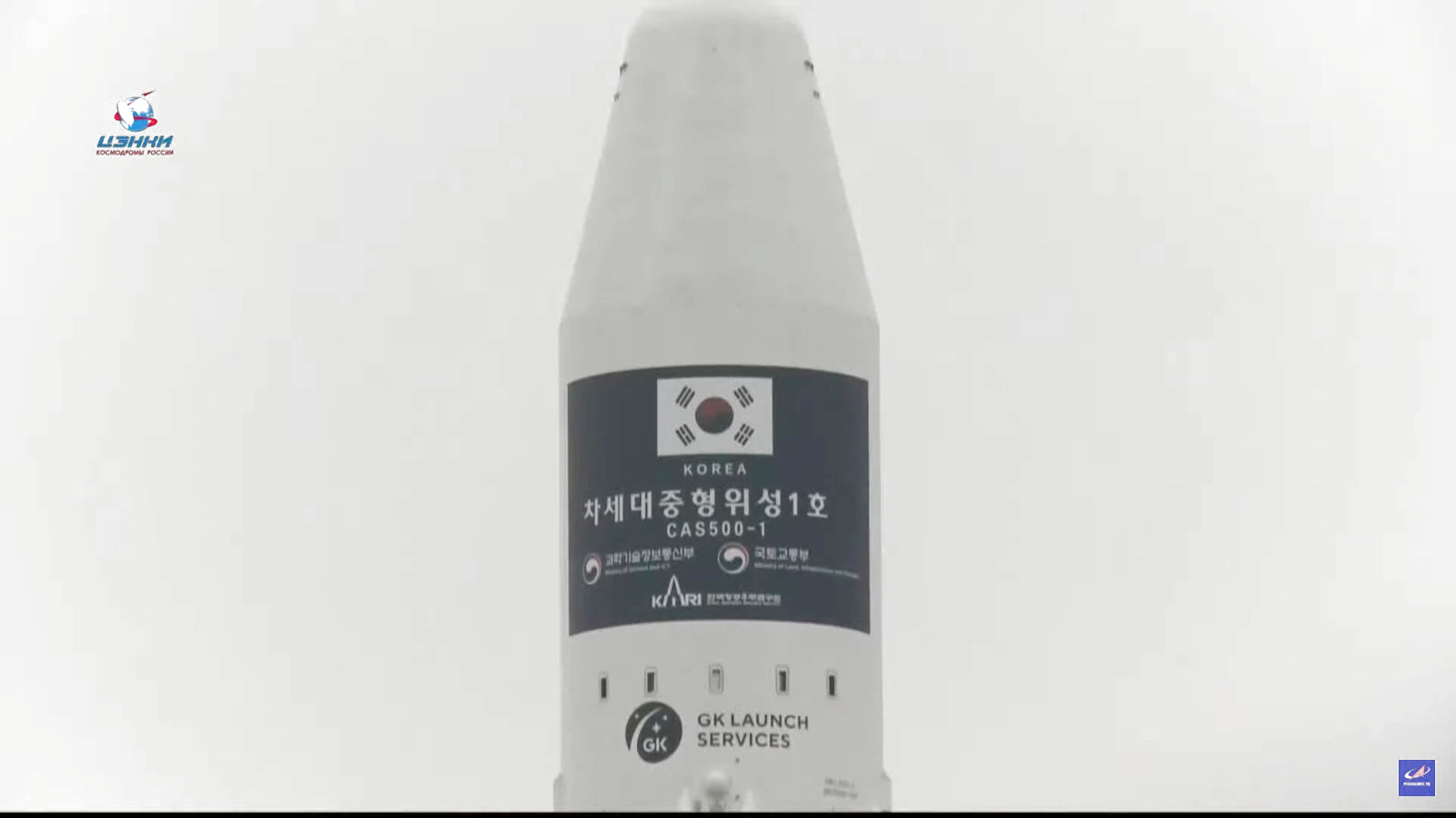
The satellite at the center of the story is CAS500-1, short for Compact Advanced Satellite 500-1. When it successfully reached orbit in March 2021, it marked more than a tidy engineering win. It signaled that South Korea was strengthening its role in Earth observation, growing its domestic satellite industry, and laying groundwork for a broader national space strategy that would later include more capable homegrown launches, commercial payloads, and a deeper push into independent space infrastructure.
In plain English: this was not just a metal box getting a very expensive ride uphill. It was a strategic milestone.
The Launch That Put CAS500-1 in Space
CAS500-1 launched aboard a Russian Soyuz 2.1a rocket with a Fregat upper stage from the Baikonur Cosmodrome in Kazakhstan. It was the lead payload on a rideshare mission packed with dozens of other satellites, which is the orbital equivalent of carpooling, except the fare is much higher and everyone absolutely has to arrive on time.
After launch, the satellite was deployed into a sun-synchronous low Earth orbit at roughly 500 kilometers altitude. That orbit matters. A sun-synchronous orbit allows a satellite to pass over the same parts of Earth at nearly the same local solar time, which gives imaging teams more consistent lighting conditions. For mapping and land observation, consistency is gold. It makes it easier to compare images across days, seasons, and years without playing a never-ending game of “Is that a real change or just weird lighting?”
CAS500-1 was also no toy-sized experiment. At roughly 500 kilograms, it was a serious Earth-observation platform designed to support practical imaging missions rather than just prove a concept and wave politely from orbit.
What Kind of Satellite Is CAS500-1?
CAS500-1 is part of South Korea’s next-generation midsize satellite effort, built to collect high-resolution imagery of Earth. Its imaging system is designed to capture 0.5-meter panchromatic imagery and 2-meter multispectral imagery. That means it can deliver detailed black-and-white images for sharp spatial detail, plus color and near-infrared data that are useful for analyzing vegetation, land cover, water, urban development, and environmental conditions.
This is where the mission gets especially interesting. The phrase “mapping satellite” can sound a little dry, as if the spacecraft’s daily routine is filing paperwork with clouds. In reality, a satellite like CAS500-1 can support a wide range of applications, including:
- digital map production and updates
- land-use and land-cover monitoring
- agricultural analysis
- forest and vegetation studies
- disaster response and damage assessment
- infrastructure and urban-growth tracking
- environmental monitoring
That range is a big part of the satellite’s appeal. A single well-designed Earth-observation platform can help governments, researchers, and commercial users make smarter decisions on the ground. It is one of those rare technologies that can serve science, planning, business, and public safety without needing to be reintroduced at every dinner party.
Why Sun-Synchronous Orbit Matters So Much
Sun-synchronous orbit is a favorite for Earth-observation missions because it delivers stable viewing conditions. NASA explains that satellites in these orbits pass over the same locations at roughly the same local time, keeping sunlight angles more consistent. That may sound like a small technical detail, but it is huge for image comparison. If you are tracking shoreline erosion, crop stress, new road construction, wildfire scars, or flood spread, you want the lighting to behave itself.
Think of it this way: if you are trying to compare two photos of the same backyard, it helps if one was not taken at sunrise and the other at sunset while your neighbor’s oak tree was throwing dramatic shadows like it was auditioning for a noir film.
Why This Mission Mattered for South Korea
CAS500-1 mattered because it sat at the intersection of three big national goals: better Earth observation, stronger domestic industry, and greater space independence.
First, the mission added a modern optical imaging asset to South Korea’s satellite portfolio. High-resolution Earth-observation systems help reduce dependence on outside providers and give a country more control over how frequently it can gather images, how quickly it can process them, and how flexibly it can support civil or strategic needs.
Second, the program was designed not only to build a satellite, but to help transfer technology and know-how from public research institutions to private industry. That is a major step in the maturation of any national space sector. Space programs become more durable when they are not built as one-off heroic acts, but as repeatable industrial processes.
Third, CAS500-1 arrived during a period when South Korea was steadily expanding its ambitions in launch vehicles, reconnaissance capabilities, communications, and lunar planning. In other words, this mission was part of a bigger sentence, not a stand-alone word.
From Foreign Launch Services to Homegrown Launch Capability
One reason CAS500-1 stands out is timing. It launched before South Korea’s Nuri rocket fully established itself as a dependable homegrown launcher. That makes CAS500-1 feel like a bridge between two phases of the country’s space story: the period of relying more heavily on foreign launch services, and the later push toward launching more of its own payloads on domestically developed rockets.
That transition became clearer over the next few years. In 2022, South Korea successfully used Nuri to put satellites into orbit. In 2023, the rocket carried a commercial-grade satellite mission. By 2025, South Korea launched another CAS500-series Earth-observation satellite, CAS500-3, on Nuri, showing how quickly the program evolved from “Can we do this?” to “We are now building a repeatable pipeline.”
That is how serious space capability grows: one orbital milestone at a time, with fewer dramatic speeches and a lot more checklists.
What Mapping Satellites Actually Do on Earth
The value of a mapping satellite is easiest to understand when you stop thinking about orbit and start thinking about outcomes on the ground. Satellite imagery is not just for pretty visuals or weather anchors pointing at giant screens. It is operational infrastructure.
USGS has long documented how satellite imagery supports land-cover mapping, urban growth analysis, agriculture, and environmental monitoring. High-quality imagery helps agencies and private firms detect change across large areas more efficiently than ground surveys alone. It can show where cities are expanding, how farmland is shifting, where coastlines are eroding, and how forests are changing over time.
It also becomes especially valuable during emergencies. Satellite-based emergency mapping has been used globally for rapid assessment after major disasters, and USGS has highlighted how fast access to good imagery can support rescue and disaster-management authorities during crises such as major hurricanes.
That is where a satellite like CAS500-1 earns its keep. It is not simply producing images; it is producing decision-making material. A good Earth-observation satellite turns geography into something measurable, comparable, and actionable.
Why Resolution Still Matters
CAS500-1’s 0.5-meter panchromatic capability is not the final word in commercial imaging resolution, but it is more than respectable. It is detailed enough to support serious mapping and monitoring work, especially when paired with multispectral data. In remote sensing, the goal is not always to chase the tiniest possible pixel. Often the real goal is to balance detail, coverage, revisit capability, and data usability.
A satellite that reliably produces consistent, analysis-friendly imagery is often more useful than one that wins a spec-sheet beauty contest but creates bottlenecks downstream. Space technology, like kitchen appliances, is judged by what it actually helps you do.
CAS500-1 and the Bigger South Korean Space Story
CAS500-1 also matters because it reflects how South Korea has been broadening its space priorities. The country’s space development has increasingly touched civilian observation, commercial services, navigation goals, communications, disaster monitoring, and national security. Reuters reporting has described South Korea’s program as part of a broader strategic push that includes satellites, next-generation communications, surveillance assets, and long-term lunar ambitions.
That does not mean every satellite is a military tool or every launch is part of a dramatic geopolitical showdown. But it does mean space capability is now woven into how modern countries think about technology leadership, economic competitiveness, resilience, and sovereignty.
CAS500-1 helped show that South Korea was not just buying access to space. It was building institutional confidence, industrial depth, and operational experience. Later progress with Nuri and additional satellite programs only reinforced that point.
What Came Next
After CAS500-1, South Korea’s space story kept moving. The Nuri program recorded successful launches, more satellites entered orbit, and additional Earth-observation and reconnaissance missions advanced. Some planned launches had to be reworked as geopolitical realities shifted; for example, contracts involving Russian launch services became harder to maintain after the invasion of Ukraine and related sanctions. That forced rescheduling and alternative launch planning for some South Korean satellites.
But if anything, those disruptions underlined the value of domestic launch capability and a more self-sufficient space ecosystem. A nation that can build, launch, and operate more of its own hardware is simply harder to sideline.
The Human Experience Behind a Satellite Reaching Orbit
Here is the part that gets lost in technical summaries: when a mapping satellite reaches orbit, the experience on the ground is a strange mix of tension, pride, exhaustion, and delayed celebration. The launch itself is loud and cinematic, sure, but the emotional center of the mission is often quieter. It lives in control rooms, engineering reviews, data pipelines, and the first moments when a spacecraft answers back.
Imagine the people involved. Engineers who have spent years arguing over tolerances, thermal behavior, optics, software, power budgets, and test anomalies suddenly have to wait through a launch timeline where none of their expertise can speed up the clock by even one second. Once the rocket lifts off, the hard part is no longer building the machine. It is trusting it.
For mission teams, orbit is not the ending. It is the beginning of a different kind of stress. They still need separation, stabilization, communication, health checks, and eventually usable data. A satellite reaching orbit is like a student getting into college: wonderful news, but now the real work starts and somebody still has to pay attention to the schedule.
There is also a national experience tied to missions like this. Space achievements have a way of compressing years of invisible effort into a single public moment. Most people will never read an optical payload specification or care deeply about orbital inclination, yet they instantly understand that placing a satellite in space is hard, prestigious, and meaningful. It feels like evidence that a country’s scientific and industrial systems can do difficult things under pressure.
Then there is the downstream human experience, which is less glamorous but arguably more important. Researchers wait for imagery that can improve land analysis. Mapmakers look for cleaner, newer data. Officials preparing for floods, wildfires, or storm damage want better situational awareness. Urban planners, agricultural analysts, and environmental scientists all benefit when a new imaging source becomes available. A successful launch can ripple outward into hundreds of practical tasks that never make headlines.
That is what makes a mission like CAS500-1 satisfying beyond the launch footage. It is not just about the rocket or the satellite. It is about building a tool that helps people understand change on Earth more clearly. In a world crowded with noise, blurry claims, and stale data, a reliable imaging satellite is refreshingly straightforward. It goes up, looks down, and brings back evidence.
And that may be the most compelling experience of all: the quiet confidence that comes from turning ambition into a working system. South Korea did not simply cheer a launch. It added another instrument to the modern toolkit for seeing, measuring, and managing the planet. No confetti required. Though, to be fair, a little confetti would have been understandable.
Conclusion
South Korea’s mapping satellite reaching orbit was a clear sign of momentum in the country’s space program. CAS500-1 was not just a successful launch payload; it was a practical Earth-observation asset built for mapping, monitoring, and real-world analysis. By entering a sun-synchronous orbit and joining a broader push toward stronger domestic launch and satellite capability, the mission became a symbol of technical maturity rather than a one-day headline.
In space, reaching orbit is always the first big test. In policy, industry, and science, it is often the first convincing proof that bigger plans are no longer hypothetical. CAS500-1 passed that test.
Note: This article is formatted as clean HTML body content for direct web publishing.