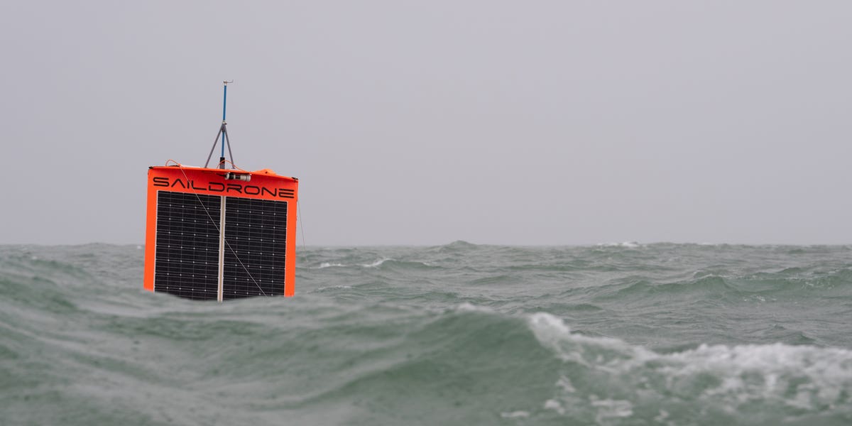
Saildrone sounds like something a pirate would invent after taking a robotics class, but it is very real: a fleet of uncrewed surface vehicles that sail the ocean collecting data, mapping the seafloor, watching maritime activity, and helping scientists understand places that are usually too remote, too rough, or too expensive to study with traditional ships.
At its simplest, Saildrone is an autonomous ocean drone company. At its most interesting, it is part research vessel, part weather station, part seafloor mapper, part maritime lookout, and part floating science intern that never asks for lunch breaks. These wind- and solar-powered vessels can travel for months at sea, carrying sensors that measure wind, waves, temperature, salinity, ocean currents, carbon dioxide, marine life signals, and other data that matter to climate science, weather forecasting, ocean mapping, fisheries management, and maritime security.
In an age when the ocean is central to climate change, global shipping, national security, food systems, offshore energy, and extreme weather, Saildrone has become one of the most recognizable names in autonomous surface vehicle technology. It is not just a cool gadget with a sail. It is a sign of where ocean intelligence is heading: persistent, lower-emission, data-rich, and increasingly automated.
What Is Saildrone?
Saildrone is a U.S.-based company that designs, manufactures, and operates uncrewed surface vehicles, often called USVs or ocean drones. The company was founded by engineer Richard Jenkins, whose background in wind-powered speed technology helped shape the rigid wing design that makes Saildrone vehicles so distinctive.
Unlike many marine drones that depend heavily on fuel or frequent support, Saildrone vehicles use wind for propulsion and solar power for onboard electronics. That combination allows them to stay at sea far longer than many crewed vessels can economically remain on station. A traditional research ship may need a large crew, fuel, port logistics, and a serious budget. A Saildrone can quietly keep working in remote waters, sending data back to shore while looking like a tiny orange sailboat that got accepted into MIT.
How Saildrone Works
The signature Saildrone design includes a tall rigid wing, a slim hull, solar panels, navigation systems, satellite communications, and mission-specific sensor packages. Operators can monitor and direct the vehicle from land, while the onboard systems manage navigation, collision avoidance, power use, and data transmission.
Wind and Solar Power
The wing acts like a sail, but it is engineered for efficiency and durability. Instead of flapping canvas and dramatic movie-sailor shouting, the rigid wing automatically adjusts to wind conditions. Solar panels power the sensors, computers, communications, and control systems. This setup reduces fuel needs and helps Saildrone operate in remote areas without requiring constant ship support.
Sensor Payloads
Different Saildrone models can carry different sensors. Depending on the mission, a vessel may measure atmospheric pressure, wind speed, wave height, water temperature, salinity, dissolved oxygen, carbon dioxide exchange, ocean currents, acoustic signals, bathymetry, or vessel activity. In plain English: it can listen, look, measure, map, and report back without anyone having to stand on deck in sideways rain holding a clipboard.
Real-Time Data
One major advantage of Saildrone is that its data can be transmitted to shore in near real time. For scientists and forecasters, that matters. Ocean data collected after a mission is still useful, but real-time observations can help weather models, hurricane forecasts, maritime monitoring, and operational decisions while events are still unfolding.
The Main Saildrone Platforms
Saildrone has developed several vehicle classes, each designed for different mission types. The three best-known platforms are Explorer, Voyager, and Surveyor.
Saildrone Explorer
The Explorer is the smaller, long-endurance platform often associated with environmental monitoring and ocean research. It is designed for persistent meteorological and oceanographic data collection, including missions in harsh environments. This is the little orange workhorse that can spend months at sea, gathering data where buoys are scarce and crewed vessels are costly.
Saildrone Voyager
The Voyager is a mid-size platform built for coastal and regional missions. It can support maritime domain awareness, coastal mapping, ocean monitoring, and missions where more payload power and speed are needed. Think of Voyager as the practical middle child: bigger than Explorer, more flexible for security and mapping, and probably the one you would ask to organize the garage.
Saildrone Surveyor
The Surveyor is the large, blue-water platform designed for long-range ocean mapping, deep-ocean survey work, and advanced payloads. It can support high-resolution bathymetric mapping, which is essential because much of the seafloor remains less mapped than many people assume. Humanity has mapped Mars with impressive enthusiasm, yet large parts of Earth’s own ocean floor still look like “here be question marks.”
Why Saildrone Matters
The ocean covers more than 70 percent of Earth’s surface, but it remains difficult and expensive to observe. Satellites are powerful, but they cannot measure everything below the surface. Buoys are valuable, but they are fixed in place. Crewed research ships are capable, but costly and limited by weather, fuel, crew safety, and scheduling.
Saildrone fills a gap between satellites, buoys, ships, aircraft, and underwater vehicles. It can travel through remote regions, stay on mission for long periods, and collect high-resolution data at the air-sea boundary, where weather and ocean systems interact. That boundary is extremely important for understanding storms, heat exchange, carbon uptake, and marine ecosystems.
Saildrone and Hurricane Forecasting
One of Saildrone’s most famous roles is hurricane research. NOAA has used Saildrone vehicles to collect ocean and atmospheric data in hurricane-prone regions, including the Atlantic, Caribbean, and Gulf waters. In 2021, a Saildrone entered Hurricane Sam, a Category 4 storm, and captured data and video from inside extreme conditions that would be dangerous for crewed vessels.
Why does this matter? Hurricanes strengthen when they draw heat from the ocean. Forecasting rapid intensification is one of the hardest challenges in tropical meteorology. Better measurements of surface winds, waves, pressure, sea surface temperature, and upper-ocean conditions can improve scientists’ understanding of how storms feed on ocean energy.
A hurricane does not politely announce, “Excuse me, I will now intensify rapidly.” It changes based on heat, moisture, wind shear, ocean mixing, and atmospheric structure. Saildrone gives researchers another tool for measuring those interactions directly, especially in the dangerous zone where the ocean and atmosphere are essentially wrestling in public.
Saildrone and Climate Science
Climate science depends on accurate ocean observations. The ocean absorbs a huge amount of heat and carbon dioxide, influencing weather patterns, marine ecosystems, sea level, and long-term climate trends. But the most important regions are often the hardest to measure.
Saildrone missions have included work in the Southern Ocean, one of the roughest and most climate-relevant areas on Earth. The Southern Ocean plays a major role in global carbon exchange, but sending crewed ships there is expensive and risky. Autonomous surface vehicles can help collect carbon dioxide measurements, ocean temperature data, and atmospheric observations for longer periods and across wider areas.
This does not replace traditional research ships. Instead, it complements them. Crewed vessels remain essential for complex sampling, deep-water operations, equipment deployment, and human scientific judgment. Saildrone expands the observing network, giving researchers more eyes and instruments in places where the ocean usually gets away with being mysterious.
Saildrone and Seafloor Mapping
Seafloor mapping is another major Saildrone application. Bathymetry, or the measurement of ocean depth and underwater terrain, is important for navigation, tsunami modeling, habitat protection, offshore energy, undersea cables, and scientific research.
Large survey ships can map the seafloor with powerful sonar systems, but they are expensive to operate. Autonomous survey vehicles can help reduce costs, extend coverage, and gather data in remote areas. Saildrone’s larger platforms are designed to support ocean mapping missions from nearshore areas to deep ocean environments.
Better seafloor maps are not just for scientists who enjoy underwater topography the way some people enjoy sourdough starters. They support safer shipping routes, smarter offshore infrastructure planning, marine conservation, and better models of ocean circulation and tsunami risk.
Saildrone and Maritime Domain Awareness
Saildrone also serves government and defense-related missions involving maritime domain awareness. That phrase means understanding what is happening at sea: vessel movements, illegal fishing, suspicious activity, search-and-rescue context, border security, and the protection of critical maritime areas.
Uncrewed surface vehicles can patrol large areas for long periods while using radar, cameras, automatic identification system data, acoustic sensors, and machine-learning tools to detect and classify activity. Human operators remain part of the process, but autonomous systems can help reduce the burden of constant monitoring across vast waters.
This is especially relevant because the ocean is enormous. Asking a small number of crewed ships to watch everything is like asking one lifeguard to supervise the Pacific Ocean with binoculars and optimism. Persistent autonomous systems give agencies another layer of awareness.
Benefits of Saildrone Technology
Lower Operational Cost
Crewed ships are powerful but expensive. They need fuel, crew, maintenance, port calls, food, safety systems, and complex scheduling. Saildrone vehicles can reduce the cost of collecting certain types of ocean data, especially on long-duration missions where constant human presence is not necessary.
Reduced Risk to People
Storms, polar waters, and remote oceans are dangerous. Sending an uncrewed vehicle into hazardous conditions can collect valuable data without putting sailors, scientists, or pilots in unnecessary danger. If a Saildrone has a rough day, nobody has to call their family and explain why they were standing on deck inside a hurricane.
Persistent Data Collection
The biggest value may be persistence. Many ocean processes change over days, weeks, months, and seasons. A vessel that can remain on station for long periods can capture changes that short research cruises might miss.
Environmental Efficiency
Wind propulsion and solar-powered electronics help reduce the fuel footprint of certain missions. Saildrone is not a magic wand that makes ocean operations impact-free, but it can make many observation tasks more energy efficient than sending a large crewed vessel.
Limitations and Challenges
Saildrone is impressive, but it is not perfect. Autonomous surface vehicles face rough seas, biofouling, sensor maintenance issues, communications limitations, navigation complexity, and the need to avoid other vessels. They also cannot perform every scientific task that a full research crew can perform.
There are also policy and governance questions. As autonomous maritime systems become more common, regulators and maritime organizations must address safety, data ownership, privacy, navigation rules, cybersecurity, and responsible use. The technology may be sleek, but the paperwork still wears steel-toed boots.
Real-World Examples of Saildrone in Action
Hurricane Sam
When Saildrone entered Hurricane Sam in 2021, it demonstrated that autonomous surface vehicles could survive and measure extreme storm conditions directly. That mission became a high-profile example of how ocean drones can support hurricane science.
Southern Ocean Carbon Research
Saildrone missions around Antarctica have supported carbon dioxide research in one of the world’s most difficult marine environments. These observations help scientists study whether parts of the ocean are absorbing or releasing carbon dioxide under changing climate conditions.
Coastal and Security Monitoring
Saildrone vehicles have been tested and used for maritime awareness missions, including government agency work involving vessel detection, surveillance support, and monitoring remote maritime regions. In these roles, Saildrone acts as a persistent sensor platform rather than a traditional patrol vessel.
Ocean Mapping
Surveyor-class missions support bathymetric mapping, helping improve knowledge of seafloor shape and structure. This data can be useful for science, navigation, infrastructure planning, and marine protection.
The Future of Saildrone
The future of Saildrone sits at the intersection of climate science, ocean exploration, artificial intelligence, maritime security, and robotics. As sensors improve and autonomous systems become more reliable, ocean drones may become a standard part of the global observing network.
We may see more Saildrone vehicles supporting hurricane forecasting, offshore wind planning, fisheries monitoring, marine mammal protection, underwater infrastructure inspection, border security, and large-scale seafloor mapping. The best use cases are those where endurance, safety, and data quality matter more than human presence.
The biggest shift is mental. For centuries, ocean data collection meant sending people and ships into hard places. That will still happen, but now the tool kit includes autonomous vessels that can loiter, listen, measure, and map without needing bunks, coffee, or motivational speeches.
Experiences and Practical Reflections Related to Saildrone
Thinking about Saildrone from a practical user experience perspective, the most impressive thing is not simply that the vehicle moves without a crew. Autonomous movement is exciting, yes, but the real value is the experience of turning the ocean from a blank space into a readable system. For scientists, forecasters, agencies, and ocean managers, Saildrone changes the daily experience of working with marine data.
Imagine being a hurricane researcher watching a storm develop. In the past, much of the available information came from satellites, aircraft, buoys, and models. Those tools are powerful, but each has gaps. A Saildrone inside or near the storm adds direct surface-level observations from one of the most chaotic places on Earth. That experience is like finally getting a microphone into a room where the ocean and atmosphere have been arguing for centuries.
For a marine scientist, the experience is also about patience. Ocean research often involves waiting: waiting for ship time, waiting for safe weather, waiting for instruments to be recovered, waiting for data processing. Saildrone does not eliminate waiting, but it changes the rhythm. A long-duration vehicle can keep gathering information while researchers stay onshore, plan the next step, and monitor incoming observations. It makes ocean science feel less like a rare expedition and more like a continuous conversation.
For coastal managers, Saildrone can support a more complete view of what is happening offshore. Fisheries, shipping lanes, marine protected areas, and offshore infrastructure all depend on accurate situational awareness. A persistent uncrewed platform can help identify patterns that occasional patrols may miss. The experience becomes less reactive and more informed. Instead of saying, “Something happened out there last week,” managers can move closer to saying, “We can see what is changing right now.”
There is also a public-facing experience. Saildrone’s hurricane footage, orange hulls, and robotic sailing profile make ocean technology easier to understand. Many people find climate data abstract, but a small autonomous vessel battling massive waves is concrete. It gives the public a visual story: this is how scientists collect information; this is why ocean data matters; this is what innovation looks like when it gets wet.
From a business and technology standpoint, Saildrone also offers a lesson in focused design. The company did not try to build a floating Swiss Army knife on day one. Its core idea was endurance through wind and solar power, then sensor payloads were adapted around mission needs. That is a useful innovation pattern: solve the energy and persistence problem first, then expand the applications.
The experience is not all smooth sailing, literally or metaphorically. Operating in saltwater is brutal. Waves punish hardware. Biofouling creeps onto surfaces. Communications can be limited. Sensors require calibration. Autonomous navigation must be reliable because the ocean is full of ships, storms, wildlife, and surprises with poor scheduling habits. Anyone evaluating Saildrone should admire the technology while remembering that ocean robotics is not a calm laboratory demo. It is engineering in a washing machine the size of a planet.
Still, the larger experience is optimistic. Saildrone shows how autonomous systems can help humans understand the planet without always placing humans in risky environments. It also demonstrates that climate science, ocean mapping, and maritime safety do not have to depend only on larger ships and older methods. The future of ocean data may be quieter, smaller, cleaner, and more persistent. It may look like an orange robotic sailboat crossing rough water, doing the unglamorous work of measuring reality one data point at a time.
Conclusion
Saildrone is more than a futuristic boat with a fancy sail. It is a practical response to one of the biggest information gaps on Earth: the ocean. By combining wind propulsion, solar-powered electronics, autonomous navigation, and mission-specific sensors, Saildrone helps collect data for hurricane forecasting, climate research, seafloor mapping, fisheries awareness, and maritime monitoring.
The ocean is too large, too important, and too under-observed for old tools alone. Saildrone does not replace ships, satellites, aircraft, buoys, or human expertise. It extends them. It gives scientists and agencies a persistent, lower-risk, and often more cost-efficient way to observe the marine world. In a future shaped by climate change, extreme weather, ocean infrastructure, and maritime security, that kind of persistent ocean intelligence will only become more valuable.
Note: This article is written for web publication in standard American English, using real publicly available information about Saildrone, autonomous surface vehicles, NOAA hurricane research, ocean mapping, climate science, and maritime domain awareness. Direct source links are intentionally not inserted into the article body.